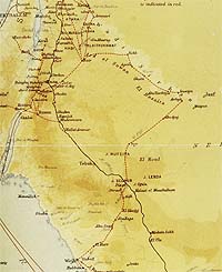
[ MAP A ]
Route of `Aqaba expedition copied from coloured maps appended to the SP Subscribersí Edition, 1926, and reproduced in the 1922 Oxford Edition edited by Jeremy Wilson in 1997.
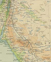
[ MAP B ]
GSGS2957 First Edition, 1924, 1:4,000,000, showing the same section as MAP A
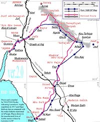
[ MAP C ]
Corrected route as compared with the wrong one mentioned on MAP A
map design : YAGITANI Ryōko, revised in 2008
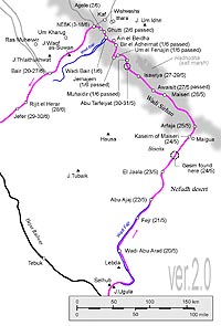
[ MAP D ]
Details of Wadi Sirhan
map design : YAGITANI Ryōko, revised in 2008
For information:
[ MAP E ]
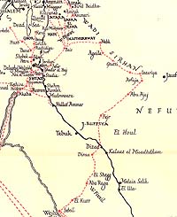
From the map in red and black, Revolt in the Desert, Cape, London, 1927
[ MAP F ]
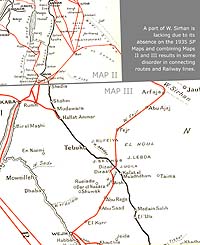
A combine of MAP II and MAP III, from the 1935 SP, Cape, which contains four of fold maps in red and black.
[ MAP G ]
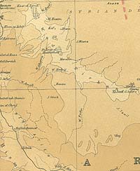
Bartholomew's Map of the Middle East, [1922], 1:4,000,000.
John Bartholomew & Son Ltd.
[the same section as Map D]
[ MAP H ]
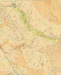
GSGS2555 First Edition, 1:1,000,000.
Compiled, drawn and printed at the War Office, 1918
[the same section as Map D]
Notice: MAP A, B, C, E and F reduced into the same scale.
Map B, G, H and J reproduced by permission of the Trustees of the National Library of Scotland.
[ MAP I ]
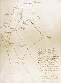
A roughly pencilled map by TEL, drawn in 1920. From Malcolm Brown: Lawrence of Arabia: the Life, the Legend, Thames & Hudson, London, 2005
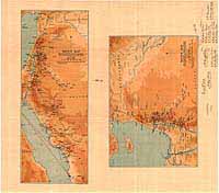
[ MAP J ]
Sketch maps prepared for Seven Pillars of Wisdom, 1926 (56.2 X 49.5cm)
John Bartholomew & Son Ltd.
See article [ More Maps ]
|
The purpose of this article is to follow the expedition of T. E. Lawrence (hereafter TEL) from Wajh to `Aqaba as described in Seven Pillars of Wisdom (hereafter SP) and to correct his route which has been erroneously shown in all of SP and SP-related books.
The most well-known map of Arabia now available for SP readers is a 4-sheet set contained in the Penguin Edition of SP, which were drawn by A. Gatrell on the basis of four maps in the SP Abridged Edition published by Jonathan Cape in July 1935, only two months after TELís death. Regretfully, these maps, as divided in sequence, do not present the whole ride route to `Aqaba on one plate. In particular, Wadi Sirhan area, one of the main portions of `Aqaba expedition, is partly lacking. The route is, however, obtainable from a Sketch Map inserted in Revolt in the Desert [MAP E], published by TEL himself in 1927. Before that, only the 1926 Subscribersí Edition of SP had contained three fold maps in colour (44.2 x 17.1 cm, 44.2 x 17.1 cm for Hijaz campaign and 22.6 x 33.5 cm for Syria campaign) which featured a red line indicating the ‘general direction of some of the journeys in this book.í They were the prototype of the Sketch Map of Revolt in the Desert, and the fountainhead of all the subsequent maps mentioned in SP and SP-related books published thereafter up to the present.
Accordingly, the map being treated here is, 1926 SP Map which indicates `Aqaba expedition route [MAP A] (*1). The 1926 SP Map bears the following notes: ‘Adapted from War Office material, as embodied in / G.S.G.S.2957, by permission of Controller H.M.S.O. / 1:4,000,000í (*2). Checking GSGS2957 First Edition [MAP B], “compiled, drawn and printed at the War Office in 1924,” proves the content identical with the 1926 SP Map.
I tried to locate the accurate positions of wells, oases, villages, etc. along TELís way, mostly his halting or camping grounds, and compared his actual routes thus confirmed on MAP C, digitally produced by Ms. YAGITANI from the materials as mentioned in Note *5 below, with those believed to have been so for such a long time.
All the quotations are from SP, The Complete 1922 Text, J. and N. Wilson, Fordingbridge, Hampshire, 2004, Book IV (Chapters 41 through 58), out of which Chapters 46 to 50 directly concern the mapping problems. It corresponds to Book IV (Chapters 39 through 54) of Abridged Edition of 1935 (in Penguin Books, 1962). Quotations from SP are shown in angle brackets.
Names of places and persons are shown usually in the transliterated form from Arabic usually omitting the article “al” (or an-, as-, at-, etc. as the case may be) and macrons (we use ˆ for macron on this page) for the simplifying purpose, but adding the forms TEL applied in writing SP in the square bracket, thus «al `Îsâwîyah» is written here as «`Isawiyah [Isawiya]» and «an Nabk» as «Nabk [Nebk]» etc. This should help the readers to ascertain the location of the places on the updated maps or atlases, because TEL used to write Arabic names transcribed in his own style, so that they are very often not found on the maps.
This article is the co-work of the writer, TASUMI, who is responsible for reading SP and finding facts, and YAGITANI who mainly takes charge of making maps being used here, obtaining old materials from the British Library, London, the National Library of Scotland, Edinburgh, and the National Diet Library, Tōkyō. TELís letters quoted here are from those, as mentioned later, provided by Mr. Jeremy Wilson, and The Letters of T. E. Lawrence, edited by Malcolm Brown, 1988.
I wish to add that this is to revise and to complete my previous observation posted on the T. E. Lawrence Studies List of 12 November 2006, under the title ‘Seven Pillars Map.í
1 ‘Epic of the Desertí (*3)
In the hot afternoon of 9 May, 1917, TELís party departed the Red Sea town of Wajh [Wejh] for `Aqaba [Akaba] by way of Wadi Sirhan deep in the far north. He wrote, and did as he planned: ‹It was obvious that from Wejh we had only one road: to march inland through the Billi hills: to cross the railway, and pass through the Fejr desert to Wadi Sirhan by Jauf: and then to march up Wadi Sirhan and westwards to Jefer, in front of Maan. There we could concentrate, and either strike at Maan or slip round it, and march down the Turkish line of defences to Akaba. This was the unguarded way, the line of least resistance, and the only possible one for us. It would be an extreme example of a turning movement, since it would involve us in a desert march of perhaps six hundred miles to capture a trench within sight of our ships: but there was no alternative,…(p.240)›
The party, usually riding camelback, with some on mares, comprised, Sharif [Sherif] Nasir, the leader, deeply committed to Faysalís [Feisal's] cause, of 27 years of age and a brother of the Amir of Medina but of a Shi‘a family; TEL and Auda Abu Tayi; Nasib al Bakri [Nesib el Bekri], a Damascene land owner of importance; Zaki [Zeki] Bey, a Syrian officer from Damascus and Nasibís companion: the 17 Agayli bodyguards and a few others to which 19 Agayls were added soon after; and Audaís and some Huwaitat [Howeitat] tribal followers. In total they were about 50 in number, which had swollen to more than 500, with those enlisted on the way, accompanied by 2,000 allies from various tribes, plus 700 Turkish prisoners including 42 officers, when TELís party finally took `Aqaba on 6 July, with a loss of only 2 lives on their side.
When the party set off from Wajh, they had ample rifles and ammunition in addition to packs of explosive gelatine for blasting rails or bridges, carried 45 pounds of flour for each of members as a ration for 6 weeks, increased later on by 14 pounds, and 22 thousand pounds sterling in gold which Faysal gave them as the wages for the party and the new men who would come to join. When they reached `Aqaba, they had nothing to eat and to spend except for their own camel-meat and green dates. They were almost starving and Nasir was in heavy debt to tribal Shaykhs, which necessitated TEL having to arrange with Admiral R. M. Burmester as soon as he arrived at Ismailia to ship all the food available in Suez, and eventually in Cairo with General Allenby to send 16 thousand pounds sterling in gold to the waiting Nasir and party at `Aqaba.
This is all about TELís and Nasirís and Audaís `Aqaba expedition.
After leaving Wajh with Faysalís good wishes, they halted at the ruined fort of Subayl [Sebeil] at the back of Wajh, then marched under moonlight, slept a couple of hours, and started 10 May with the sun to the northeast by north till in the late afternoon they arrived at the valley of Kurr [el Kurr].
The valley was ‹a first outlier from the foothills of the Shefa, the coastal ridge and backbone of Arabia (p.244).› Here was a green garden and fortunately, they met a party of Rasim, the Egyptian gunner, Mahmud the doctor and Maulud, the Iraqi cavalryman and others, all chiefs under Faysal. Auda also met friends, including a relative and messenger of the great chieftain Nuri Shaalan on their way to greet Faysal. And there was also a solitary, sedentary old man with his wife and daughters, having nothing to do with and sneering at the Arab revolt. Labouring day and night he grew some vegetables, dates, and among other things tobacco which was his most profitable crop, selling it annually at Wajh market to buy something to wear.
TEL was very unfit for the journeys as the boils on his back and fever, perhaps an after-effect of so-called Red Sea dysentery, rebounded. When it was decided to stay there to meet the party of Sharif Sharraf, who, out for raiding the Hijaz [Hejaz] Railway, would be coming back in a few days, TEL was much pleased.
Sharraf did not show up against their expectations and Auda, a man of the desert, did not like to stay idle in the green valley any longer. They started on the second night at 2 a.m., rode a whole day, and camped at a well in the valley named `Ayn `Arnawa [Ain Arnoua]. The next morning, 12 May, they started and went round a very steep spur to climb it by zigzagging, where they had to dismount to climb on all fours and unload the food and explosives. Here 2 camels were lost. They camped at a well called Abu Sa`d [Saad] and the next day, 14 May, at Abu Raqa [Raga, Ragga], which TEL thought was the southernmost part of the coloured rocky mountains of Petra in the far north.
The camels were weak, victims of mange which infested Wajh. TEL was suffering badly from boils and fever, and pains from a sweaty saddle sore. They stayed there for 3 days waiting for Sharraf. This was a good rest for TEL and also it was here that he hired 2 Agayli youths Dawd [Daud] and Farraj, as an unexpected result of punishment they received for their mischievous behaviour.
At last the party of Sharraf arrived and from him TELís party took 19 Agayls for additional escort for the gold-sacks they had been carrying on camelback.
- On 17 May they left Abu Raqa and began a long, waterless march through the plain of [El Shegg] (location unascertained). The party rode through the maze of rock islands and pinnacles and crevasses in the most desolate country, guided only by Audaís unusual sense of direction in the daytime, and by the Pole Star in the night with Auda singing old Huwaitat songs which TEL could not understand.
They met accidentally with Captain H. S. Hornby, RE and Colonel S. L. Newcombeís pupil in blasting rails, coming back from the railway to get supplies at Wajh. Arabs used to complain “Newcombe is like fire. He burns friend and enemy.” They also had told TEL that ‹Newcombe would not sleep except with his head on the rails, and that Hornby would worry the metals with his teeth when guncotton failed (p.255).›
‹Nothing in the march was normal or reassuring (p.257).› They felt they ‹were in an ominous land, incapable of life, hostile even to the passing of life except painfully along the sparse roads that time had laid across its face (pp.257-6).› After marching a full 2 days, they camped on 18 May evening in Wadi `Ashsh [Aish], finding ‹a very little water in holes which someone had scooped, probably after the rainstorm of three weeks ago (p.258).›
On 19 May, they started at dawn for the limpid water pools at Dir`a [Diraa] and as it was now quite near the railway, they had to drink their stomachsí full and fill their ‹few water skins, all ready for the long dash to Fejr (p.259).›
That late afternoon, they crossed the Hijaz Railway unmolested, at a point just north from Dizad, between Tabuk and Qal`at al Mu`azzam. Then they fixed guncotton and gelatine dynamite to as many of the rails as they had time to reach, and lit the fuses. The hollow valley was filled ‹with the echoes of our repeated bursts (p.261).› Auda, who ‹had not known dynamite before (idem),› ‹was moved to a rush of hasty poetry on the glory of the noise (idem).› They also ‹cut the three telegraph wires, and fastened the free ends to the saddles of six riding camels of the Howeitat. The astonished beasts struggled far into the eastern valleys with the growing weight of the twanging, tangling wire and the bursting poles dragging after them (idem).›
The next morning, on 20 May, just as the day broke they started and went almost due north for the long journey toward Wadi Fajr. All day long they rode and covered about 50 miles, and camped in the bed of Wadi Abu Arad [see MAP D] for a night without marching farther, as it was all they could do at a stretch with sick camels, and the ‹district was in the line of raiding parties, …and in the hours of darkness there were no friends in Arabia (p.265).›
The next day, 21 May, at the height of noon TELís party reached the Bi`r (well) Fajr. ‹We were now half-way across the open country to the Sirhan, with half our danger and trouble freely passed. Our spirits rose, and we spoke of news of the Howeitat at the reported flood-pool of Abu Ajaj on the morrow (p.266),› TEL wrote.
On 22 May, they started before dawn as usual but after barely 2 miles they had to stop because of the heat and glare of the desert, and stayed in some shelter to pass mid-day till 2 in the afternoon, and started again to reach Khabra` (pool after rain, or a small oasis) Abu Ajaj before sunset. There they searched for the Huwaitat tracks but could not find any. They were gone, probably having decamped ten days before and headed for Wadi Sirhan.
The next morning, 23 May, the party left Khabra` Abu Ajaj and rode northeast by north to a group of wells of `Arfajah, whereby they aimed at entering the lower Wadi Sirhan, passing over a vast, flat, empty, no-manís land which was called Bisayt [Biseita] meaning a carpet. In the evening they came to the top of a sand ridge named Ja`ala [Jaala] and slept there peacefully. According to the maps to be mentioned later, this is exactly a midway point between Fajr and `Arfajah.
The next day, 24 May, was to become memorable for the rescue of Qasim [Gasim] by TEL when he was lost in the scorching Bisayt. He was one of TELís bodyguards though he was no Agayl but from Ma`an, ‹a fanged and yellow-faced outlaw, who fled into the desert and joined the Howeitat after killing a Turkish official in a dispute over cattle-tax. Crimes against tax-gatherers had a sympathetic side to all of us, and this gave Gasim a specious rumour of geniality which, we discovered later, was actually far from the truth (p.242).›
TEL, solely out of a sense of duty and not from humanity, had turned his unwilling camel round, and forced her back into the emptiness behind.
When TEL finally caught up the party with Qasim who had gone nearly insane from horror and heat and thirst sat on his camelís rump, no one praised his deed. Auda said he would not have let TEL go back had he been present, and struck Qasim sharply. Nasib went so far as to blame TEL for such a whim to Nasir, saying it was clear to him that TEL must have reckoned they would come back.
That evening, they decided not to go farther and camped at Qusaym `Arfajah, contentedly even without a mouthful of water, because they were already at the south bank of Wadi Sirhan and `Arfajah was within their sight.
On 25 May, at 8 oíclock in the morning, TELís party reached the wells of `Arfajah. This ended the first leg of his journey for the `Aqaba raid.
Now, until up to Bi`r Fajr there seemed to have been little problem in the matter of mapping TELí s route. But, as seen on MAP A, Abu Ajaj has always been shown at the middle between Fajr and `Arfajah, or even upward, without indicating Ja`ala the midway camping site. As mentioned earlier, Abu Ajaj was a water pool located within half a dayís ride of Fajr, whereas the party took 2 days and 2 nights after Abu Ajaj before they got to `Arfajah. The distance between Fajr and `Arfajah as the crow flies is about 100 miles. Abu Ajaj should not be more than 30 miles apart from Fajr, if the description in SP is correct. As a matter of fact, Abu Ajaj is marked in on the TPC H-5B Edition 5-GSGS map, at a point only 15 miles northeast of Fajr as shown here on MAP C.
The misplacing might not have been so serious a matter if it had been a lone case. In reality, however, this is a beginning of successive wrong mappings of places inside Wadi Sirhan.
2 Wadi Sirhan
TEL wrote that the Sirhan was ‹the famous roadway, camping ground, and chain of water holes that in a series of linked depressions extended from Jauf, Nuriís capital, in the south-east, northwards to Azrak, which lay opposite Amman, and Deraa, near Jebel Druse in Syria (p.177).› He had first reported of it in Geographical Notes, Arab Bulletin dated 21 October 1917, condensing all of what he had seen and experienced in and around the valley. Wadi Sirhan, the ‘Valley of Wolfí, ran almost straight for over 220 miles and about 20 miles across, and TEL and his party traveled more than half of it, or approx. 120 miles starting from `Arfajah on 25 May till 3 June, before they came out of the Wadi near Nabk heading for Bayir in the south.
TELís movements in the Wadi are as follows.
-
25 May : Dismounted at `Arfajah at 8 in the morning, assaulted at night while camping and drinking coffee by 20 camel-mounted raiders, one Agayl shot.
26 May : Marched for 5 hours in the morning and 12 miles in the afternoon, camped at Maysari [Maiseri].
27 May : Marched fast for 5 hours in the morning, halted at Uwaisit [Awaisit], started 1 p.m., marched for 3 hours, met a Huwaitat shepherd, rode fast for 1 hour together and came to `Isawiyah, a camping ground of Audaís clan, received warmly and feasted in the evening very late. Stayed for 3 days, grandly feasted everyday.
30 May : Marched for 3 hours to Abu Tarfeiyat (location unascertained), stayed for 2 days. Feasted till all but Nasir and TEL got sick. Annoyed greatly by innumerable snakes, some of them poisonous. Snakes were ‹swimming in the pools, or clustering in thick knots around their brinks (p.289).› At night, they could be found under or on the blanket. Three men died of the bites. They killed 20 snakes daily but it was nothing. Those including TEL who always had a shuddering, increasing horror of snakes which got on their nerves, longed that their ‹stay in Sirhan might end (idem).›
1 June : Left Abu Tarfeiyat in the morning, reached the lava field of Mukhaydir [Muhaidir], passed the wells of Umm al [Um el] Fenajin (Fanajil?) and Jamajam [Jemajem], arrived at Qulban (well) al `Uzaymat [Bi`r el Adheimat]. Found this the very western edge of the Sirhan, joining Ardh as-Suwan (‘District of Flints,í an area now in Jordanian territory running parallel to Wadi Sirhan). Looking eastward, the salt marshes of Hazawza [Hadhodha] could be seen. `Ayn (well) al Bayda [Ain el Beidha] was 3 miles away and Jabal Umm Idhn [Jebel Um Idhn] 20 miles. TEL saw ‹the landscape was of a hopelessness and sadness deeper than all the open deserts (p.292).› ‹There was something sinister, something actively evil in this snake-devoted Sirhan waste, so pregnant with salt water, fruitless palms, and unprofitable bushes which served neither for grazing nor for firewood (idem).› They hated it so much that they ‹made a night march to be out of it sooner (idem)› and camped in Wadi Bayir.
Lady Anne Blunt, wrote 38 years earlier on her departure in January, 1879, from Kaf to Jawf, as the first European woman to travel inner Arabia, “The Wady Sirhan is a curious chaotic depression, probably the bed of some ancient sea like the Dead Sea, …There are numerous wells both here [Ithra, Kafís twin oasis] and at Kaf, wide and shallow, for the water is only eight feet below the surface of the ground (*4).” She was not troubled with snakes, because her travel was done during winter, as was the case with the most of Arabian travellers to evade heat.
-
2 June : Left at dawn Wadi Bayir for `Uqaylah [Ageila] (most probably adjacent to or annexed with Nabk) by way of Ghatti [Ghutti], entered Nuriís empty house in `Uqaylah to spend a night there.
3 June : Moved to Nabk Abu Qasr [Nebk Abu Gasr] (or ‘An Nabk,í or ‘Nabk al Gharbí = Nabk of the West, probably against a place of the same name of Nabk Abu Qasr in lower Sirhan, north of `Arfajah), which was the palm-grove with a mud house of Nuri Shaalan. This had been appointed for their rally place, as it was near to villages like Kaf, Ithra [Ithara], etc.
By the meeting of TELís party with Audaís clan, the first purpose of the marches covering 2 sides of a quadrangle made of Wajh, `Arfajah, Nabk and `Aqaba was accomplished. The rest was the long ride going down southwest by south to `Aqaba via Bayir [Bair], Jafr [Jefer] , Ghadir al Haj (south of Ma`an), Abu Lasan [Aba el Lassan] and Quweira [Guweira].
It included TELís two long ‹excursions (p.293)› or deviations northwards, made firstly for intelligence purpose, while Nasir was still raising the new men (560 strong, 100 of which were left to safeguard the Huwaitat tribespeople) at Nabk, to as far north as Damascus, perhaps even to Palmyra and Ba`albek, of which very little has yet been made known: secondly, during Nasirís stay in Bayir, to the north of Amman to attack the railway in order to distract the attention of the Turks from the south. On this second occasion, TELís small party with Zaal, Audaís cousin as leader, and 110 men left Bayir, went almost up to Dar`a, destroyed the railway, burnt a station building, killed a few Turks, took some booty, and returned after a week with no casualty. All these accounts, however, relating to the third side of the marchesí quadrangle, followed by attack on `Aqaba, are outside the problem of the maps.
The partyís movements in Wadi Sirhan as above-mentioned show the routes, or more properly the location of places indicated in MAP A and therefore in every SP-related map, are wrong.
Nearly all of the Wadi Sirhan places mentioned in SP are ascertainable on many of the newer maps, the particulars of which are mentioned in Note (*5) below, though not any one of them is enough to locate all the places. The writer obtained these maps stored in NDL (the National Diet Library, Tōkyō), only to find that the latest edition is not necessarily the best, because some of the places visited by TEL seem to have disappeared forever. For us, the 1960 ‘Al Jawfí map is the most useful at the moment.
If the accurate routes thus confirmed in MAP C are compared with MAP A, the difference is conspicuous. In other words, even though the length of Wadi Sirhan from Azraq to Jawf in both maps is about the same, the distance between Nabk and `Arfajah, Lawrenceís track, is reduced by more than 12 percent. Thus, while the total length of the Sirhan is 220 miles, Nabk - `Arfajah distance in the SP 1922 Oxford Text [MAP A] and Revolt in the Desert [MAP E] is 105 miles, against the actual distance of 120 miles (in approx. figures as the crow flies). The SP abridged 1935 edition carries no place-name of Nabk but naturally shows a similarly shortened route as above.
A remarkable mistake seen in all those erroneous maps is the disproportionate nearness of `Isawiyah from `Arfajah. Supposing the walking pace of tired camels to be 4 miles an hour, the mileage counted from the above mentioned itinerary, would be somewhere around 60 miles, and it is really so on the above mentioned ‘Al Jawfí and other maps, since `Isawiyah is located in the middle between Nabk and `Arfajah; while MAP A shows it to be less than 20 miles!
The same thing occurs in a reverse way. On MAP A, Nabk, `Uqaylah and Ghatti have been separated to the maximum range of over 40 miles, as if to recover the loss incurred in the `Isawiyah - `Arfajah part lower down, though these 3 names can be found in a small area of less than 15 miles across.
Altogether, TELís traveling in Wadi Sirhan has been reduced by about 15 percent and swung to the south by about 50 miles, equivalent to nearly one tenth of his entire march from Wajh to `Aqaba. Gertrude Bell deplored the wrong maps bitterly when she traveled north of Azraq in 1905, saying “The makers of the Palestine Exploration map have allowed their fancy to play freely over the eastern slopes of the Jebel Druze. Hills have hopped along for miles, and villages have crossed ravines and settled themselves on the opposite banks…”(*6). A similar thing must have occurred to the makers of the SP 1926 map.
How such a distortion could be applied to the seemingly simple matter of following TELís desert and Wadi marches is the result of two errors. One is why it was brought about initially and the other is why the mistake remained uncorrected for such a long time since 1926 until now. The answer for this last was simply that all the readers of SP and SP-related books have never doubted the printed track of TEL and never noticed its errors.
At any rate, TEL had been in Cairo with Army Intelligence in his capacity as a map-making officer, which might convince his readers that his own route would be correct.
The first question is however not that easy. In his lifetime TEL published two SP versions, namely the SP Subscribersí Edition and Revolt in the Desert. As mentioned already, the virtual inaccessibility to the former due to its extreme rareness has made the latterís ‘Sketch Mapí the model of all later maps.
The error caught the writerís attention while perusing SP, The Complete 1922 Text. On the ground of the Authority mentioned GSGS2957, 1:4,000,000 on its map, YAGITANI spared no effort to collect the maps made before 1926, and to draw the comparative and accurate maps. While working on this map study, she found that GSGS2957 First Edition [MAP B] itself was not entirely accurate. For instance, the Hijaz Railway together with places along its lines, is shown below the present Jordan-Saudi Arabia boundary southward, more easterly than its actual route. This results markedly in placing two important SP towns Mada`in Salih [Medain Salih] and `Ula [El Ula] to the east of Long. 38° E, whereas in actual fact they both are located to the west of that longitude. This is a cartographical problem, not concerned with the route of the `Aqaba expedition. The specific error has been corrected in the GSGS2957 Third Edition published in 1941, yet the SP 1926 Map, produced from the 1924 GSGS2957 First Edition, is still now printed with these errors.
The conclusions based on an assumption are as follows:
1. TEL had his oil compass, but there is no mention in SP to suggest he carried any kind of map with him while on the march, though as a map-maker in Cairo he must have borne in mind the rough geography of inner Arabia. In any event, the mapping of the Wadi Sirhan area was very poor at that time, as can be seen from the [1922] Bartholomew's Map of the Middle East [MAP G], of Bartholomew (*7) and the 1924 GSGS2957 First Edition [MAP B]. Thus none of the places referred to in the above itinerary of TEL was marked in on both of them except Uwaisit, Ghatti and Kaf.
2. Consequently, the lack of a proper map might have worried TEL very much when he wrote SP. It is evident from some of his letters about maps written in middle 1920s, which Mr. Jeremy Wilson posted on his mailinglist, TELawrence Studies in 2003, although, according to him, many of the letters to Bartholomew had been sold through salerooms and are unavailable. One of such letters, with no date written sometime in May, 1926 when TELís struggle with the SP Subscribersí Edition was at last nearing its end, says:
I am glad you can undertake the map I require. I enclose the rough compilation I have made, for the black plate. I require all the names on this draft to be shown: they have been put down reasonably in their normal places: but the matter of accuracy is a secondary consideration. In Arabia one works, geographically, to a margin of 30 miles' error! (TELawrence Studies List, 16 August 2003)
I suspect that TEL had no way other than asking Bartholomew to fill up the map with the places he had visited during the war. TELís correspondence hints at unsatisfactory talks with the War Office on the maps. He wrote to D.G. Hogarth, then President of the Royal Geographical Society, on 2nd April asking him for a reliable cartographer.
The W.O. have finally found themselves too busy to tackle my map. So I want to get into touch with the next-best firm. It has just occurred to me that you, as the R.G.S., can probably find out for me their name and address. The material is all there, and the W.O. will give me transfers of their plates: but I want a new black (name) plate made. I'd prefer the names “written”, not “typed”: and I'd like them well done.
If you can get me an address of a really good firm I'll write to them and explain myself. (Not a big job. 300 names. 400 copies. A good draughtsman. A printer.) That's all. (idem)
Bartholomew was recommended as the result.
On 21 May 1926, TEL wrote to Colonel Robert Buxton:
The map is a delay just now. I've done my draft of it: but Bartholomew […] are not yet started, because the Stationery Office have not yet granted them the right to use copyright W.O. material. It will be all right -- before the end of July. (idem)
Then on 14 July, to Bartholomew:
Your sketch seems to me to fit excellently. I have made a few changes, and wiped a good deal off the blue plate. (idem)
Eventually on 22 August 1926, according to TELís letter to Mrs. Charlotte Shaw (MB Letters, p.304), he visited Bartholomew in Edinburgh and finalized the map.
Presumably, TELís memory of the desert and barren Wadi with no landmarks had partly sunk into oblivion after exactly 9 years, and he did not notice the discrepancies arising between the locations as placed by Bartholomew and the real ones.
The problem can be shown by a few pages of writing and a sketch map that TEL scribbled on All Souls College, Oxford writing paper on 11 August 1920, to Leonard Gotch, a former colleague in Cairo. It is shown on pp. 80-81 of Malcolm Brown: Lawrence of Arabia, the Life, the Legend, Thames & Hudson, London, 2005, as reproduced here [MAP I]. Apart from the close-up of the `Aqaba area and TELís “private journey of my own, for intelligence purpose” to the north showing him reaching Tadmor (Palmyra), which will be of great interest for that matter, the sketch of the `Aqaba expedition route reveals a startling error. This sketch shows that he proceeded to Azraq from Kaf, then straight down to Bayir. As previously mentioned in the itinerary, this is totally wrong. Apparently he sadly confused `Aqaba route with those of his 2 northern diversions taken on his way to `Aqaba. This means confusion had already taken place in 1920, although, perhaps, he should not be blamed for his poor memory, considering all the featureless country he traveled 3 years earlier.
Probably it was the entire campaign map of the Arab revolt that TEL wanted Bartholomew to fill in, causing TEL in 1926 to regard “the matter of accuracy” as “a secondary consideration.” The `Aqaba route, however significant it might be, was but a section of his whole activities. As a result, he did not mind “a margin of 30 milesí error” and might have accepted Bartholomewís mapping and used it immediately for the SP Subscribersí Edition and then the next year for Revolt in the Desert, which has been copied and followed time and time again by so many writers.
However, the writer found another map GSGS2555, the First Edition of which was issued as early as 1918 [MAP H], and this was one of principal Authorities for GSGS2957. Compared with the [1922] Bartholomew's Map of the Middle East [MAP G], or even with the 1924 GSGS2957 [MAP B] itself, this is singularly much more detailed, as far as TEL's route in Sirhan is concerned, though the background of its making is unknown to me. Of course, it is not likely that TEL would have seen this map. What can be said though is that all the SP maps would have been different and correctly marked in, had he seen GSGS2555 before he went to Bartholomew.
To the best of my knowledge, I have heard of no one who had mentioned the wrong route, only excepting Alain Fillion: Lawrence díArabie au Moyen-Orient, Éditions du Félin, Paris, 2005.
I obtained the book and read it recently finding a map showing a wrong route for `Aqaba, similar to MAP A / MAP E here, but only to illustrate the distribution of major Arabic tribes, and a series of 1998 Ministry of Defence, London, maps indicating various stages of TELís activities by overwriting them, including naturally the `Aqaba campaign. This results in presenting two inconsistent maps in one book.
Mr. Fillion states that to give the maps to the readers of SP is one of the bookís two purposes, another being explication of TELís political foresight in Middle Eastern history, when the present French versions of SP or Revolt in the Desert have no precise maps whatsoever, leaving the readers in everlasting uncertainty on the location of TELís activities. In other words, Mr. Fillionís intention is only to show TELís actual course of overall activity, and not to show how the maps in the past were printed with wrong routes of the `Aqaba campaign, nor to correct them. Indeed, the route shown in the book from Fajr to `Arfajah is again wrong, in that TELís entry into the Sirhan is indicated westerly by more than 10 percent of his correct distance within the Wadi.
These imperfections are more than regretted.
Another reference I know of to TELís route is a contribution in The Journal of the T.E. Lawrence Society, Vol. XIII, No. 2, Spring 2004, entitled “T.E. Lawrence: A Sketch Map, Extract from Strolling About on the Roof of the World by Hugh Leach and Susan Farrington: Chapter x by John Shipman”. The note contains TELís sketch map thought to have been sent to Douglas Carruthers. I would like to mention that the map appears to be more correct by far than MAP A and MAP E. The sketch map covers the `Aqaba expeditionís first leg, i.e. the portion from the Hejaz Railway to `Arfajah. Although the print is not very clear, places like Kh. `Ajaj, Ja`ala, mountains like J. Rufaiya and J. Umm Ragaiba, and other names not mentioned in SP, are shown in relatively but surprisingly proper locations. It might well have been because TELís original sketching was made, as mentioned in the said note, on the spot in his war-diary now kept in the BL (Add. MSS 45915 [Is this not 49515?]). Only I wonder why the map-conscious TEL did not do the same while in the Wadi Sirhan, not to speak of his rough and erroneous sketch for Leonard Gotch.
The gratitudes of YAGITANI and the writer are due to Mr. Jeremy Wilson for the help in giving us, among others, useful information pertaining to the SP 1926 Map, including TELís correspondence in mid-1926 with John Bartholomew, Edinburgh and others; to Mr. Christopher Fleet, Deputy Map Curator, National Library of Scotland, Edinburgh, for providing with us Middle East maps made in late 1910s and early 1920s including the first editions of GSGS2555, 2957; to Mr. David McClay, of NLS, for looking into the Bartholomew Archives for the older Bartholomew material, which, however, turned out to have stored neither originals of SP 1926 map nor TELís letters; and to Mr. David Jamieson, Map Librarian, HarperCollins Publishers Ltd., for their kindness in searching relevant data. And our special thanks to Mr. John William Duckworth, for his kind advice.
*1 [back]
The SP Subscribersí Edition of 1926, is a very rare book, and is hard even to have a look at for the general reader. The use of the map in this book has been made possible by the reprint of an original kept in Cambridge University Library, which Mr. Jeremy Wilson photographed while editing the Complete 1922 text of SP, and appended in the book, published in the editions of 1997, 2003 and 2004. We are deeply indebted to him for his publishing the map on his website too, saying “the website version is the only other ‘publicationí of these maps I know of.” That the above-cited endpaper maps were taken from 1926 SP is also mentioned in: http://www.castlehillpress.com/bibliography/2003-sp22-spec.htm
*2 [back]
G.G.G.S. stands for Geographical Section, General Staff; H.M.S.O. for His Majestyís Stationery Office.
*3 [back]
NAKANO Yoshio (1903-1985), a Shakespearean scholar at the University of Tōkyō, named SP in introducing the life of Lawrence as early as 1940. His work, Arabia-no Lorens [Lawrence of Arabia], though compact, has long been one of the best works on Lawrence in Japanese. Nakano once revealed a proposal he heard of while he was still a student in early 1920s, to invite Lawrence as successor to Robert Nichols for the Universityís chair of English literature. The idea did not materialize because Lawrence declined the offer as evidenced in his letter of 13 January, 1924 to Sydney Cockerell. The post was filled by Edmund Blunden.
*4 [back]
Lady Anne Blunt: A Pilgrimage to Nejd, the Cradle of the Arab Race. A Visit to the Court of the Arab Emir, and “Our Persian Campaign,” 1881, Chapter V.
*5 [back]
- GSGS2555, Asia 1:1,000,000. Sheet North H-37, ‘Al Jauf,' 3rd Edition, [London], 1944.
- International Map of the World (IMW) / Series 1301 1:1,000,000. Department of Survey, War Office and Air Ministry. [London]
‘Al Jauf' Series 1301, Sheet NH-37, Edition 7-GSGS. 1960.
‘Al Jawf' Series 1301, Sheet NH-37, Edition 9-TPC. 1969.
- Operational navigation chart (ONC) 1:1,000,000. Sheet H-5, Edition 7-GSGS. Director of Military Survey, Ministry of Defence, [London], 1982.
- Tactical pilotage chart (TPC) 1:500,000. Sheet H-5B, Edition 5-GSGS. Director of Military Survey, Ministry of Defence, [London], 1991
*6 [back]
Gertrude Lowthian Bell: The Desert and the Sown, 1907, Chapter V.
*7 [back]
John George Bartholomew, 1860-1920. Celebrated Scottish cartographer, grandson of the founder of John Bartholomew & Son, Ltd., map publishing company in Edinburgh. The 1922 Times Survey Atlas of the World, among his many works, took 15 years to make and was completed after his death by his son, John. His name is still inscribed in the present-day Times Atlas. In 1989 John Bartholomew & Son, Ltd. merged with the Glasgow publisher Collins, as part of the multinational HarperCollins Publishers.
Following the search of documents pertaining to TEL's map-making for 1926 SP subscribers' edition, information came recently from NLS (National Library of Scotland), Edinburgh, of their finding a set of maps and several letters sent from Bartholomew to TEL, along with some relative entries in the Bartholomew office books. I understand that there is a special project underway on Bartholomew Archive of NLS.
The maps had been kept in the Archive, 'bound in a large ledger.' They had to be taken off the ledger and flattened before getting a high-resolution image with 'a sheet-feed scanner.' Two maps had the titles
“Campaigning in the Hedjaz 1916-17” and “Campaigning in Syria, 1917-18” respectively, and were none other than those prints made for TEL's need to be used in SP Subscribers' Edition.
With the Library's permission, the image of maps [MAP J] is shown here:
From Bartholomew's four outgoing letters sent from 14 May to 12 July 1926, and office books, some of the facts were discovered. They include:- That the order was received on 6 July 1926, for '2 sections map Arabia from MO transfers, 6 printings, 400 each,' at a charge for the work (copperplate, drawing, printing etc), totally amounting to GBP65.
That according to the printing record, 435 copies were made on 1, October 1926, That there was a letter dated 7 October thanking Lawrence for payment of GBP65 and for his 'kind remarks.'
Also according to a copy of receipted Invoice for the said sum of Bartholomew, which NLS obtained from Bodleian Library, Oxford, the actual number of maps delivered to TEL was 404 copies [JOHN BARTHOLOMEW & SON LTD., cartographers to the King/ Invoice to T.E.Lawrence, 1926/ MS. Eng. c. 6744, fol. 51]. This would just suffice 202 volumes of Subscribers' Edition.
The reason why NLS could not find so far any letters sent to TEL was
simply that they were addressed to T.E. Shaw, Cranwell and classified
in the Archive in that name, not by T. E. Lawrence.
(TASUMI, Aug. 2008)
|

TASUMI Tsuneo
Arabia no Rorensu no Shinjitsu: Chie no Nanahashira wo Yominaosu [in Japanese]
Heibonsha, 2013
ISBN978-4-582-44119-2 C0022
3,780yen
TASUMI Tsuneo
A Lady in the Wilderness, the Life and Works of Gertrude Bell
[in Japanese]
Hōsei University Press, Tōkyō, 2005
ISBN4-588-23807-8 C1323
5,565yen
|
TASUMI Tsuneo (Mr.) 
- Born in Ōsaka, Japan, graduated from Kyōto University majoring in law. Worked for a business concern traveling extensively, and residing in Teheran, New York and Manila. Specially interested in Gertrude Bell. Translated T. E. Lawrence's Seven Pillars of Wisdom, The Complete 1922 Text into Japanese in 2008-2009 (Five volumes, Heibonsha, Tōkyō).
- Author of:
- Kōya-ni-tatu Kifujin, Gertrude Bell-no Shōgai-to Gyōseki [A Lady in the Wilderness, the Life and Works of Gertrude Bell], Hōsei University Press, Tōkyō, 2005
Translations into Japanese:
- Lady Anne Blunt: A Pilgrimage to Nejd, the Cradle of the Arab Race, London, 1881
- Gertrude Bell: Persian Pictures, London, 1894, reprinted 1928
- Gertrude Bell: The Desert and the Sown, London, 1907
- Friedrich Rosen: Oriental Memories of a German Diplomatist, London, 1930
- Joan Haslip: Lady Hester Stanhope, A Biography, London, 1934
- Julian Huxley: From an Antique Land, London, 1954
- Thomas Joseph Assad: Three Victorian Travellers. Burton, Blunt, Doughty, London, 1964
- Taj al-Saltana: Crowning Anguish, Memoirs of a Persian Princess from the Harem to Modernity, 1884-1914. tr. by Anna Vanzan and Amin Neshati from Persian into English. ed. by Abbas Amanat, Washington, DC, 1993
- T. E. Lawrence, Seven Pillars of Wisdom, The Complete 1922 Text, Fordingbridge, 2003
|
S. Tabachnick & C. Matheson
Images of Lawrence
[Japanese version]
Heibonsha, Tōkyō, 1991
ISBN4-582-37315-1
2,650yen (out of print)
|
YAGITANI Ryōko (Ms.)
Writer, translator, illustrator. Specialising in T. E. Lawrence and Christian denominations. Lives in Saitama, Japan.
Works include:
- co-translator of Images of Lawrence by Stephen Tabachnick & Christopher Matheson, Heibonsha, Tōkyō, 1991
- co-translator of A Portrait of a Marriage by Nigel Nicolson, Heibonsha, 1992
- T. E. Lawrence: A Bibliography in Japanese, Privately Printed, 1993
- Shitte Yakudatsu Kirisutokyō Daikenkyū [A Study of Christian Denominations], Shinchōsha, Tōkyō, 2001
- editor of Nihon no Kyōkai wo Tazunete [Visiting Christian churches in Japan, Two Volumes], Heibonsha, 2002, 2004
- Kirisutokyō Saijiki [Christian Calender], Heibonsha, 2003
- Nandemowakaru Kirisutokyō Daijiten [the revised and enlarged edition of the 2001 Study of Christian Denominations], Asahi Shimbun Shuppan, 2012 [ Amazon in Japanese]
|


